Risk Maps
Interactive risk mapping tools for various environmental and property hazards.
Environmental Risk
Risk Maps
Interactive risk mapping tools for various environmental and property hazards.
Official FEMA Resources
Access the official FEMA Flood Insurance Rate Maps and additional hazard data for comprehensive risk assessment.
Visit FEMA Hazard MapsCatastrophic Perils Analysis
Our proprietary Catastrophic Perils Map integrates multiple environmental risk factors into a comprehensive visualization. This advanced tool helps insurers understand the complete spectrum of catastrophe risks affecting property portfolios across the United States.
WIND EXPOSURE
Hurricane and severe weather wind risk assessment across geographic regions
Interactive Risk Map
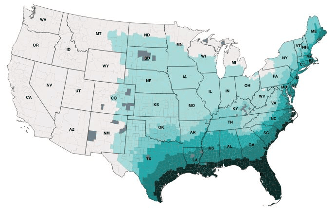
Risk Level Indicators
None – Low
Low
Moderate
High
Severe
CAT Exposed
Understanding Risk Levels
Risk levels are calculated based on historical data, geographic factors, and environmental conditions. Higher risk areas may require additional insurance coverage or mitigation strategies.
WILDFIRE EXPOSURE
Forest fire risk assessment based on vegetation, climate, and historical data
Interactive Risk Map
.png&w=3840&q=75&dpl=dpl_FQQAdHXPqAXwxHMRdZjwtTheZfht)
Risk Level Indicators
None – Low
Low
Moderate
High
Severe
CAT Exposed
Understanding Risk Levels
Risk levels are calculated based on historical data, geographic factors, and environmental conditions. Higher risk areas may require additional insurance coverage or mitigation strategies.
FLOOD EXPOSURE
Flood risk assessment including river, coastal, and flash flood hazards
Interactive Risk Map
.png&w=3840&q=75&dpl=dpl_FQQAdHXPqAXwxHMRdZjwtTheZfht)
Risk Level Indicators
None – Low
Low
Moderate
High
Severe
CAT Exposed
Understanding Risk Levels
Risk levels are calculated based on historical data, geographic factors, and environmental conditions. Higher risk areas may require additional insurance coverage or mitigation strategies.
Need Detailed Risk Analysis?
Get personalized risk assessments and comprehensive reports for your properties. Our experts can help you understand these maps and develop mitigation strategies.
More resources in this category
- Flood Map
Interactive flood risk mapping to identify flood-prone areas and assess flood insurance needs.
- Live Weather
Real-time weather monitoring and its impact on property risk assessment.
Need a Professional Assessment?
Our experts help you understand and leverage these tools for better insurance outcomes.